File:Gais AR Dorfplatz Panorama 1.jpg
Jump to navigation
Jump to search
Size of this preview: 800 × 181 pixels. Other resolutions: 320 × 72 pixels | 640 × 145 pixels | 1,024 × 231 pixels | 1,280 × 289 pixels | 6,351 × 1,435 pixels.
Original file (6,351 × 1,435 pixels, file size: 6.67 MB, MIME type: image/jpeg)
Captions
Captions
Add a one-line explanation of what this file represents
Summary
[edit]| Description |
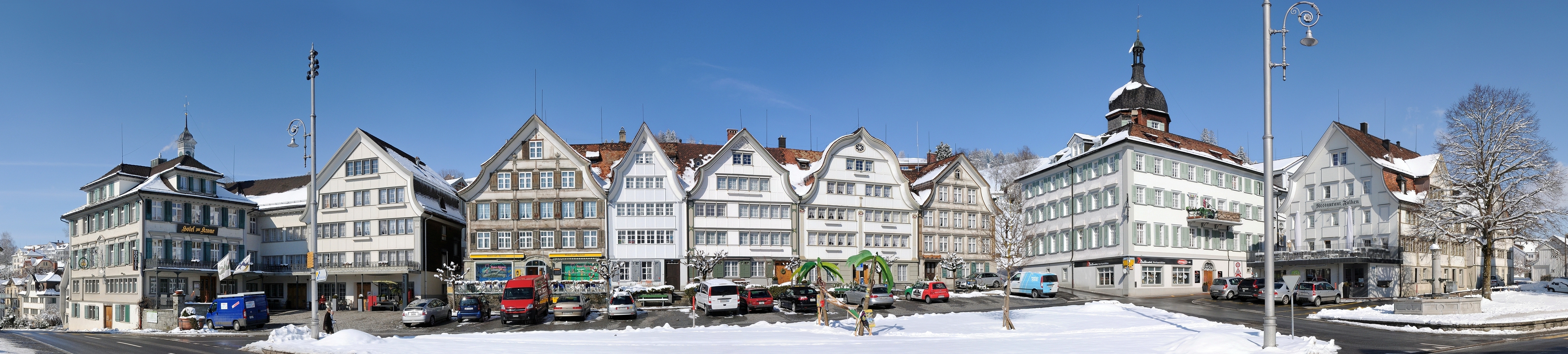
Deutsch: Panorama im Dorfzentrum von Gais. Gais ist eine politische Gemeinde im Mittelland des Kantons Appenzell Ausserrhoden in der Schweiz. Besonders hervorzuheben sind die unterschiedlichen Giebelvarianten. Français : Vue panoramique sur le centre-ville de Gais, une commune suisse du canton d'Appenzell Rhodes-Extérieures.
|
||
| Date | |||
| Source | Own work | ||
| Author | böhringer friedrich | ||
| Permission (Reusing this file) |
I, the copyright holder of this work, hereby publish it under the following license: This file is licensed under the Creative Commons Attribution-Share Alike 2.5 Generic license.
|

| Camera location | | View this and other nearby images on: OpenStreetMap |
|---|
This Photo was taken by Böhringer Friedrich.
|
Feel free to use my photos, but please mention me as the author and if you want send me a message. or (rufre@lenz-nenning.at) |
Assessment
[edit]
|
This image was selected as picture of the day on Wikimedia Commons for 26 August 2011. It was captioned as follows: Other languages:
Français : Gais est une commune suisse du canton d'Appenzell Rhodes-Extérieures. 日本語: スイス アッペンツェル・アウサーローデン準州のガイス村 |
This image has been assessed using the Quality image guidelines and is considered a Quality image.
|
File history
Click on a date/time to view the file as it appeared at that time.
| Date/Time | Thumbnail | Dimensions | User | Comment | |
|---|---|---|---|---|---|
| current | 20:37, 23 February 2011 | 6,351 × 1,435 (6.67 MB) | Böhringer (talk | contribs) | {{Information |Description= {{de| Panorama im Dorfzentrum von Gais.}} |Source= {{Own}} |Date= 2011-02-23 |Author= böhringer friedrich |Permission={{self|cc-by-sa-2.5}} |other_versions= }} {{User:Böhringer/Template:Cre |
You cannot overwrite this file.
File usage on Commons
The following 47 pages use this file:
- User:Bennylin/Cityscapes
- User:Böhringer
- User:Böhringer/Archive 3
- User:Samsara/POTY 2011 overview
- Commons:Featured picture candidates/File:Gais AR Dorfplatz Panorama 1.jpg
- Commons:Featured picture candidates/Log/March 2011
- Commons:Featured pictures/Places/Architecture/Cityscapes
- Commons:Featured pictures/Places/Panoramas
- Commons:Featured pictures/chronological/2011-A
- Commons:Picture of the Year/2011/Galleries/2011-A
- Commons:Picture of the Year/2011/Galleries/A
- Commons:Picture of the Year/2011/Galleries/A/table
- Commons:Picture of the Year/2011/Galleries/ALL
- Commons:Picture of the Year/2011/Galleries/Index/3
- Commons:Picture of the Year/2011/Galleries/Index/ALL
- Commons:Picture of the Year/2011/Galleries/Index/Panoramic views
- Commons:Picture of the Year/2011/Galleries/MAR
- Commons:Picture of the Year/2011/Galleries/Panoramic views
- Commons:Picture of the Year/2011/Galleries/Panoramic views/Large
- Commons:Picture of the Year/2011/Galleries/Panoramic views/Small
- Commons:Picture of the Year/2011/Galleries/table
- Commons:Picture of the Year/2011/R1/Gais AR Dorfplatz Panorama 1.jpg
- Commons:Picture of the Year/2011/Results/R1/ALL/table
- Commons:Picture of the Year/2011/Results/R1/Panoramic views
- Commons:Picture of the Year/2011/Results/R1/Panoramic views/table
- Commons:Potd/2011-08 (de)
- Commons:Potd/2011-08 (nl)
- Commons:Potd/2011-08 (pt)
- Commons:Quality images/Subject/Places/Man made structures/Panorama/archive 2008 to 2013
- Commons:Quality images candidates/Archives February 2011
- Commons talk:Picture of the Year/2011/Results/R1/ALL/table
- Template:Potd/2011-08
- Template:Potd/2011-08-26
- Template:Potd/2011-08-26 (cs)
- Template:Potd/2011-08-26 (de)
- Template:Potd/2011-08-26 (en)
- Template:Potd/2011-08-26 (es)
- Template:Potd/2011-08-26 (fr)
- Template:Potd/2011-08-26 (hu)
- Template:Potd/2011-08-26 (it)
- Template:Potd/2011-08-26 (ja)
- Template:Potd/2011-08-26 (nl)
- Template:Potd/2011-08-26 (ro)
- Template:Potd/2011-08-26 (ru)
- Template:Potd/2011-08-26 (uk)
- Template:Potd/2011-08-26 (zh-hans)
- Template:Potd/2011-08 (zh-hans)
File usage on other wikis
The following other wikis use this file:
- Usage on ba.wikipedia.org
- Usage on be-tarask.wikipedia.org
- Usage on bn.wikipedia.org
- Usage on crh.wikipedia.org
- Usage on cv.wikipedia.org
- Usage on de.wikipedia.org
- Usage on hu.wikipedia.org
- Usage on kk.wikipedia.org
- Usage on ko.wikipedia.org
- Usage on krc.wikipedia.org
- Usage on lbe.wikipedia.org
- Usage on mg.wikipedia.org
- Usage on os.wikipedia.org
- Usage on pl.wikipedia.org
- Usage on ru.wikipedia.org
- Usage on ru.wikinews.org
- Usage on sah.wikipedia.org
- Usage on uk.wikipedia.org
- Usage on vi.wikipedia.org
- Usage on xal.wikipedia.org
- Usage on zh.wikipedia.org